Kefalonia: Small Stories Behind the Island's Familiar Landmarks
From the De Bosset Bridge and the Katavothres to Melissani, Assos and Fiskardo: small stories that explain Kefalonia behind its most familiar images.
Kefalonia has places you recognise instantly, even if you don't always know their story. The De Bosset Bridge, the Saint Theodore Lighthouse, the Katavothres, Melissani, Drogarati, the Castle of Saint George, Assos and Fiskardo are sites that have entered the basic image of the island. Some you come across on a walk in Argostoli, others on a summer drive towards Sami, Erissos or Livathos. A few are natural phenomena, others are monuments, and some are settlements that still carry traces of another era. Behind all of them, however, are small stories that help explain Kefalonia better: how it was built, how the centre of its life shifted, how earthquakes shaped it, how its geology produced phenomena rarely seen elsewhere, and how certain places became, over time, something more than mere stops on the map.
What is interesting about these places is that most of them need no introduction. Locals have seen them many times, visitors find them quickly in their first searches, and every summer they return to the same routes, photographs and conversations about the island. What is often missing is the small context that makes them more understandable. The De Bosset Bridge was not always a place for a stroll. The Katavothres are not simply a curious spot by the sea. Melissani is not only the light on the water. The Castle of Saint George is not just an old castle with a view. And Fiskardo is not important only because it is beautiful. Behind each one lies a piece of history, geography or everyday life worth knowing.
The De Bosset Bridge: The Project That Changed Argostoli
The De Bosset Bridge is today one of the most recognisable spots in Argostoli. For many, it is the walk over Koutavos, the route with views of the town, the place where you stop for a moment to watch the movement of the bay. Its current use, however, should not overshadow its original role. The bridge was not designed as a recreational space, but as an infrastructure project that solved a real transport problem. Before it was built, connecting Argostoli with the opposite side of the bay and the inland area was more difficult, requiring either a boat crossing or a long detour around the lagoon. Once built, the town gained a new, direct connection and daily life changed in a practical and visible way.
The bridge was built in 1813, during the period of British administration of the Ionian Islands, on the initiative of Charles Philippe De Bosset, a Swiss engineer and officer who served as governor of Kefalonia. Roughly 690 metres long, it links Argostoli with Drapano, crossing the Koutavos lagoon. In its original form it was wooden; it was later replaced and reinforced with stone, taking on the form that became associated with the image of the town. In the middle stands the obelisk that recalls the period of British presence on the island. Today, the bridge has been pedestrianised and serves mainly as a public walking space, but its history shows that many of the places we now see as iconic Kefalonian scenes began as very specific responses to everyday needs.
The Saint Theodore Lighthouse: The Beacon That Became a Landmark
The Saint Theodore Lighthouse is one of those spots that often ends up in photographs without needing much explanation. It stands near Argostoli, on the coastal road to Lassi, and stands out because of its circular form. It does not look like the typical narrow, tall lighthouse most people imagine. Its appearance, with columns around the central core, made it a distinctive architectural feature of the area. Today many people see it as a brief stop on a walk around Argostoli, but its original purpose was strictly maritime. It stood at a position that served the entrance and movement within the bay, in an era when navigation and the safe approach of ships were crucial for the island's connections.
The original lighthouse was built in 1828, during British rule, when Kefalonia was under British administration and the island was seeing works on roads, ports, administration and infrastructure. Its construction is attributed to the period of Charles Napier, who served as British governor of Kefalonia. The lighthouse was destroyed by the 1953 earthquakes and was later reconstructed based on its earlier form, so as to preserve its recognisable image. This matters, because the structure we see today is both continuity and reconstruction. It is not just a picturesque spot by the sea, but a small example of how Kefalonia, after the earthquakes, tried to keep certain elements of its older image, even when much of the island had to be rebuilt from scratch.
The Katavothres: Seawater That Disappears Beneath the Island
The Katavothres of Argostoli are among the most interesting natural phenomena in Kefalonia, precisely because the sight itself is simple but the explanation impressive. At the tip of the Argostoli peninsula, near the road leading to the Lighthouse, seawater flows inland and disappears into underground sinkholes. For many years the phenomenon was puzzling, because the water did not simply pool or return immediately to the sea, but seemed to vanish along an underground path. Kefalonia, due to its limestone geology and karst formations, has underground water networks that allow such movements. At the Katavothres this geological feature is visible at a point very close to the town.
The best-known scientific confirmation of the water's route came in 1963, when Austrian geologists Josef Zötl and Viktor Maurin poured 160 kilograms of uranine, a tracer dye, into the Katavothres. About fifteen days later, the dye was detected on the eastern side of Kefalonia, in the area of Sami and Karavomylos, confirming that the water crossed underground through the island over a distance of about 15 kilometres. This route links the Katavothres with the wider hydrological system of the area, which includes Melissani and the springs of Karavomylos. So a spot that many people now see for a few minutes during a walk around Argostoli in fact explains one of the most characteristic geological phenomena of Kefalonia.
Melissani: A Cave That Is More Than Light on Water
Melissani is one of the best-known places in Kefalonia and certainly one of those that has entered the island's modern image most strongly. The lake, the opening in the roof, the light falling on the water and the boat moving inside the cave create a scene that easily lingers in memory. But that is only the first reading. Melissani is located near Karavomylos, a short distance from Sami, and is part of a wider geological system linked to the underground movement of Kefalonia's waters. The natural collapse of part of the roof opened the cave to the light, creating the image most people know today.
The modern discovery of Melissani is attributed to the speleologist Ioannis Petrochilos in 1951, and its archaeological dimension is as important as the natural one. Inside the cave, finds linked to the worship of Pan and the Nymphs have been identified, indicating that in antiquity the space was not only of geological interest but also a place of worship. The related finds have been moved to the Archaeological Museum of Argostoli. This information changes the way one looks at Melissani. It is not just a beautiful cave with water, but a place where geology, archaeology and local mythological tradition meet. That is why its value is not exhausted by the image of light reflected on the lake.
Drogarati: The Cave With a Vast Chamber and Remarkable Acoustics
Drogarati lies in the area of Haliotata, near Sami, and is often mentioned alongside Melissani because the two caves are relatively close. In reality, however, they are two very different natural spaces. Melissani is associated with water and light, while Drogarati impresses through its rock formations, depth, vast chamber and the feeling of an underground space. Its stalactites and stalagmites were formed over immense periods of time, through the action of water on limestone. The cave has a stable temperature, and visiting it offers another image of Kefalonia, far from the sea and the coastline.
The entrance to Drogarati became known, according to the available accounts, when strong seismic activity caused part of the cave to collapse and revealed its opening. The cave has been explored by the Hellenic Speleological Society and has been developed as a visitable site. Of particular interest is the large hall, known for its acoustics, a feature that has in the past allowed it to be used for musical events. Drogarati shows that Kefalonia has not only surface landscapes but also an underground world tied to the geological history of the island. It is one of the places that helps the reader understand why Kefalonia is not only beaches, but also an island with a distinctive natural foundation.
The Castle of Saint George: The Old Capital of Kefalonia
The Castle of Saint George, near Peratata, is one of the places that best explains an older Kefalonia, before Argostoli became the administrative centre of the island. It stands on a hill overlooking Livathos and much of south-western Kefalonia, a position of clear strategic importance. In eras when coastal settlements were more exposed to raids, a fortified site on a height offered better protection and control. The castle was not merely a military installation. For centuries it was a centre of administration and life, as much of the island's political and social reality was organised around it.
The fortress was the capital of Kefalonia from the Middle Ages until 1757, with its construction dated to the 12th century. From 1500 onwards, when Kefalonia passed definitively under Venetian rule, the Venetians reinforced the castle and organised public buildings inside it: the governor's seat, residences of officials, barracks, storehouses, prisons and cisterns. The transfer of the capital to Argostoli in 1757 changed its historical trajectory, as the island's centre of gravity shifted towards the sea and the harbour. Today, the Castle of Saint George is important not only as a monument, but as a reminder that Kefalonia did not always have the same geography of power and daily life that we know today.
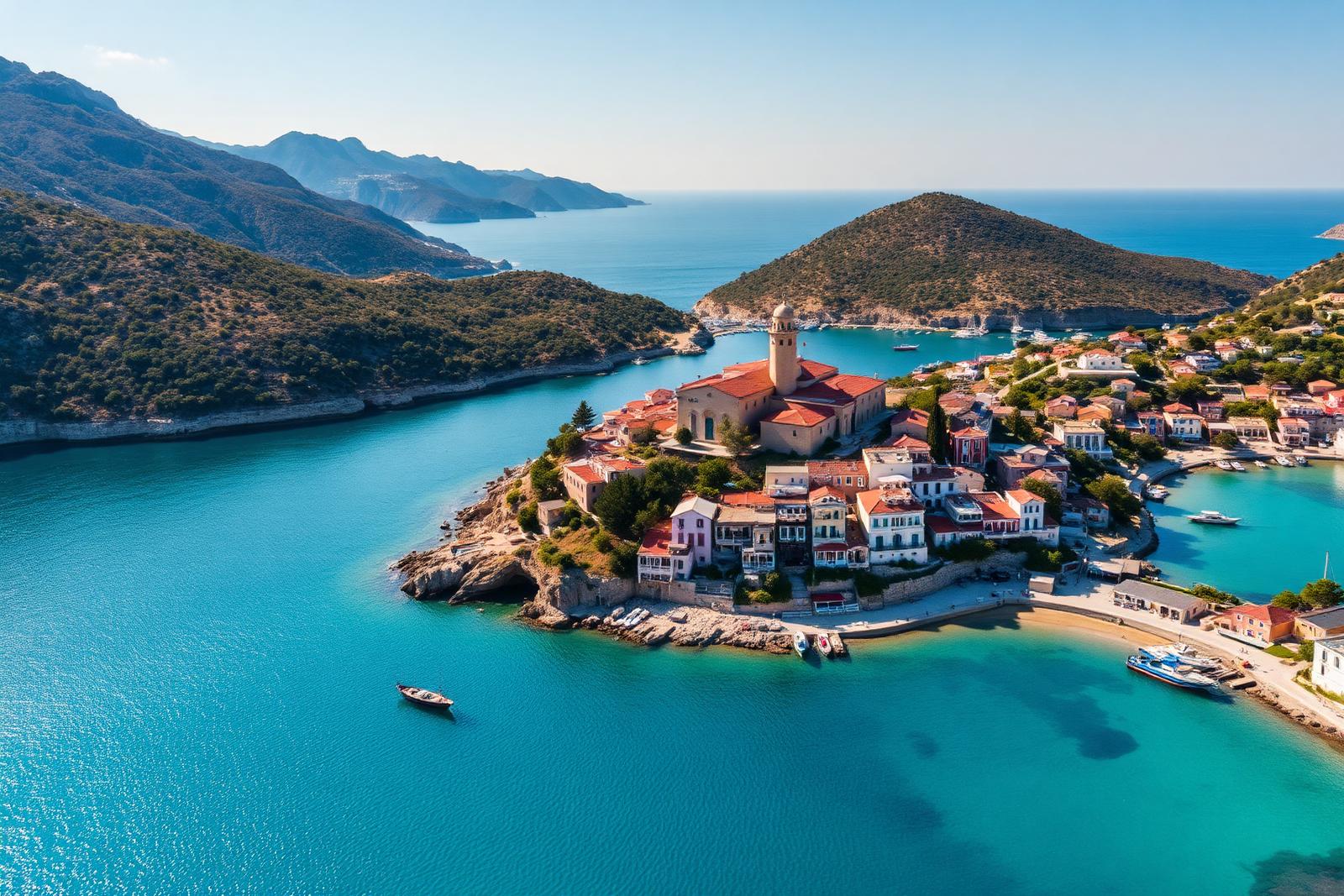
Assos: The Venetian Castle Behind the Familiar Image
Assos is one of the most recognisable spots in Kefalonia, mainly because of the image of the settlement on the narrow strip of land and the peninsula extending into the Ionian. Behind the present-day image, however, lies one of the most important Venetian fortification works on the island. The Castle of Assos sits in a naturally defensible position, with steep slopes and limited access from the isthmus that connects it to the mainland. This geography explains why the Venetians saw Assos as a site suited to defensive organisation. This was not simply a castle with a fine view, but a design linked to the protection of the island and the strengthening of the Venetian presence in the Ionian.
Construction of the Castle of Assos began in 1593, at a time when Venice was trying to reinforce its possessions in the eastern Mediterranean and the Ionian. The plan was ambitious: Assos was intended to function as a strong administrative and defensive centre. However, the isolation of the area and problems with the water supply limited its development. The castle never grew into the major centre the Venetians had imagined. Even so, its walls and the extent of the site show the scale of the original ambition. Today, the visitor sees mainly a beautiful settlement and an impressive walk up to the castle. History, however, explains why this place once held far more practical and strategic significance.
Fiskardo: A Rare Glimpse of Pre-Earthquake Kefalonia
Fiskardo holds a special place in the modern image of Kefalonia, not only because it is popular, but because it preserves to a large extent an architectural continuity that was lost in many other parts of the island. After the 1953 earthquakes, much of Kefalonia was rebuilt almost from scratch. Towns, villages and public buildings changed shape, as the destruction was extensive and reconstruction had to happen quickly and on new terms. Northern Kefalonia, however, was less affected than other areas. That is why Fiskardo retained more elements of its older Ionian architecture, with buildings that offer an image closer to pre-earthquake Kefalonia.
This does not mean that Fiskardo is simply a beautiful seaside village. Its value lies in the fact that it allows us to see, at least in part, a Kefalonia that elsewhere disappeared beneath the ruins and the demands of post-war reconstruction. Its relationship with the sea, its architectural scale, the colours and the arrangement of buildings around the harbour set it apart from other settlements on the island. For the visitor, it is one of the best-known places in northern Kefalonia. For the local, however, it is also a reminder of how decisive the 1953 earthquakes were for the image the island has today. Fiskardo shows not only what was saved, but also what was lost.
Familiar Places Become More Interesting When You Know What You Are Seeing
The common thread in all these places is that they are not merely stops on the map. The De Bosset Bridge speaks of British rule and Argostoli's infrastructure. The Saint Theodore Lighthouse shows the town's relationship with navigation and post-earthquake reconstruction. The Katavothres, Melissani and Drogarati explain why Kefalonia has such an interesting geology. The Castle of Saint George and Assos recall the era of Venetian rule, the needs of defence and the shifts in the island's centres of power. Fiskardo brings into the present a fragment of the pre-earthquake image that was not preserved everywhere. This information does not make the sites heavier. It makes them clearer.
It is also a more interesting way to see Kefalonia in summer, whether you live on the island or are visiting. You do not need to change your route, nor to treat the places as a history lesson. It is enough to know a little more about what lies in front of you. Then the walk on the De Bosset Bridge, the stop at the Lighthouse, the visit to Melissani, the drive towards Assos or the view of Fiskardo become more than just beautiful images. They become places that explain Kefalonia, its history, its geography and the way the island was shaped through time.
Related Articles
Άσσος: ο οικισμός, το φρούριο και η εικόνα που άντεξε στον χρόνο
Πώς η μικρή Άσσος της βόρειας Κεφαλονιάς συγκεντρώνει σε έναν τόπο γεωγραφία, ενετική στρατηγική, μετασεισμική ανασυγκρότηση και σημερινή τουριστική απήχηση.
Βαλλιάνειο ΓΕΛ Κεραμειών: Πρόσκληση στην εκδήλωση αποφοίτησης 2025-2026
Η τελετή αποφοίτησης του Βαλλιανείου ΓΕΛ Κεραμειών θα πραγματοποιηθεί την Πέμπτη 25 Ιουνίου 2026, στις 20:00, στο Λυκιαρδοπούλειο Θέατρο Κεραμειών.
Η ναυτική ιστορία του νησιού πέρα από τα λιμάνια
Από το παράκτιο εμπόριο του Ιονίου έως τη Μαύρη Θάλασσα, τον Δούναβη και το Λονδίνο: πλοιοκτήτες, καπετάνιοι, ναυτικοί και οικογένειες που έδωσαν στο νησί διεθνή ναυτική παρουσία.