Greece is the most seismically active country in Europe, with approximately 50% of the total seismic energy on the continent being released from the Greek area. The Hellenic arc, starting from Kefalonia, runs through the southern Ionian Sea, passes west of the Peloponnese, south of Crete, and ends east of Rhodes. This seismicity is mainly due to the collision of the Aegean microplate with the African plate, which is subducting beneath the former. Most earthquakes are shallow, while intermediate-depth earthquakes are mainly located in the back-arc region.
The Ionian Sea region, and specifically Kefalonia, is one of the most seismically active areas worldwide and the most seismically active in Greece. The geological structure of Kefalonia and Ithaca combines formations of the Paxoi unit and the Ionian unit, with the latter geologically dominating Ithaca. The rocks of Kefalonia include alpine and post-alpine formations, with tectonic pressures that have created a succession of compression and tension phases (Lekkas et al., 2001). The continuous movement of the Anatolian plate, the African plate to the north, and the Apulia plate to the northeast is considered to be the cause of the high seismicity in the Kefalonia transform zone. These tectonic movements create strong geological pressures, which are released through frequent seismic tremors.
Unfortunately, this area has experienced destructive earthquakes over the years, resulting in the loss of many human lives, as well as significant impacts at all levels. This has led the Greek Seismic Code to require all building constructions in this area to be designed based on a maximum peak ground acceleration (PGA) of 0.36 g, which corresponds to the maximum required earthquake resistance in Greece.
In general, it is worth noting that studies on the island's seismic activity, such as those by the Geodynamic Institute and international seismological organizations, have contributed significantly to improving earthquake prediction techniques and understanding. Data from Kefalonia's seismographic recordings are used in international scientific research, making the island a natural laboratory for the study of seismology.

The Strongest Seismic Tremors Throughout the Years
Historically, major earthquakes occurred in 1469, 1636, 1767, 1867, and 1953, while more recently significant earthquakes were recorded in 1983 and 2014. The most destructive earthquakes in this region were those of 1867 and 1953, with the latter being the most catastrophic of all.
More specifically, in 1469, a 7.2 Richter earthquake in Lixouri left over 500 victims. This was followed in 1743 by a 7 Richter earthquake, causing extensive damage in the Ionian. In the 1767 earthquake, with a magnitude of 7.2 Richter, Lixouri suffered severe losses with dozens of victims and the destruction of many buildings, while the region's water reserves were also contaminated, further exacerbating the local community's plight, and almost all churches were destroyed, followed by aftershocks for 40 days.
The area continued to be hit by major tremors in the 19th century, with a characteristic example being the 1867 earthquake, 7.4 Richter, which destroyed thousands of houses, churches, and monuments in Paliki and Argostoli, leaving behind a significant number of victims. Another significant earthquake was recorded in 1912, which had its epicenter in Asprogerakas and caused great damage in the Eleios - Pronnoi area.
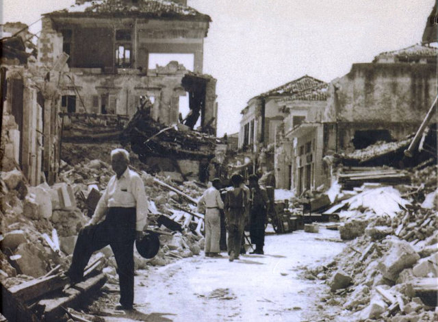
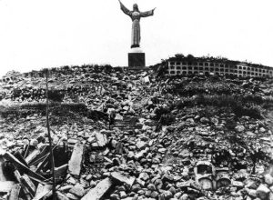
However, the most destructive earthquake in Kefalonia, with an intensity of 7.2 Richter, was recorded in 1953 and destroyed 91% of the island's buildings, causing the death of 455 people. The Ionian earthquakes of 1953 were a seismic sequence of three main earthquakes of increasing intensity that destroyed Kefalonia and Ithaca. The first earthquake occurred on August 9, causing damage in Ithaca and the town of Sami in Kefalonia. The second earthquake occurred on August 11, with its epicenter northwest of Zakynthos, and was even larger, destroying Argostoli, Lixouri, Agia Effimia, and Valsamata in Kefalonia. The third and most destructive earthquake occurred on August 12; according to McKenzie (1972), it had a magnitude of M 7.2, and a magnitude of 19 on the Modified Mercalli scale IX-X, meaning it was “Extremely Destructive.” This earthquake almost completely destroyed Kefalonia, Ithaca, and Zakynthos, and its epicenter was southeast of Kefalonia and had a reverse fault focal mechanism.
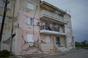
Finally, in 2014, two powerful earthquakes of 5.8 and 5.7 Richter struck western Kefalonia, causing landslides and rockfalls, but fortunately without casualties. These earthquakes were caused by faults in the Kefalonia Transform Zone and had their epicenter in Lixouri and nearby villages.
Technology and Seismological Observation in Kefalonia
Earthquakes are natural geological phenomena that result from the sudden release of energy in the Earth's crust, creating seismic waves that cause ground tremors. The tremors vary in magnitude, from imperceptible to catastrophic. In Greece, the systematic collection of macroseismic data began in 1858 by the Geodynamic Institute of the National Observatory of Athens (GI-NOA), using a network of observers and recording with the Rossi Forel (RF) macroseismic scale. Since 1950, measurements have been made on the Modified Mercalli scale, and since 1994, they have also been published electronically. Kefalonia has an extensive network of seismographs that record tremors in real-time, even micro-earthquakes of 1-2 Richter. This technology allows scientists to study the sensitivity of the subsoil to tectonic movements. The Geodynamic Institute has installed GNSS stations, such as the VLSM and KIPO stations, to monitor vibrations with high accuracy. Specifically, two GNSS stations operate in Kefalonia, in Valsamata and Kipouria, recording GPS observations at one-second intervals. The operation of these stations, since 2006 and 2010 respectively, contributes to monitoring tectonic shifts in the area.
After the 2014 earthquakes, scientific bodies from Greece and France, in cooperation with local organizations, established the Argostoli Seismological Observatory (ARGONET). This network includes seismographs in boreholes and open fields. Modern accelerographs and temporary networks have also been installed to study ground-structure interaction. At the same time, new technologies such as optical fibers are being tested for recording seismic data.
Admittedly, the assessment of an evolving seismic activity is of critical importance from the perspective of civil protection. Indeed, everyone wants to know if it is regular seismic activity (background seismicity) or a swarm, foreshocks, a mainshock, or aftershocks. The distinction is not easy in real-time.
It is noted that recent research shows that the Ionian region has increased fluidity in the Earth's upper crust, facilitating the propagation of seismic waves and the intensity of surface earthquakes. These shifts largely explain the frequent and powerful tremors that strike the island.
Earthquake-Resistant Technology in Kefalonia
The intense and continuous seismicity in Kefalonia has led to the development of one of the most advanced earthquake-resistant systems in Europe. Based on the guidelines of the European Earthquake Resistance Organization, buildings, both private and public, are constructed to withstand tremors above 8 Richter. Strict regulations, based on research by the School of Civil Engineering of the National Technical University of Athens, ensure durability, as buildings equipped with dampers, braces, and flexible foundations absorb vibrations without collapsing. In fact, research shows that these measures reduced material damage by up to 70% and injuries by 60% compared to older earthquakes.
Conclusion
Kefalonia, with its intense seismic history, experiences significant economic impacts from earthquakes, as tourism is often affected after catastrophic events. At the same time, ongoing infrastructure and upgrade projects to strengthen earthquake-resistant structures increase costs, although these investments have proven effective.
Moreover, Kefalonia has become a reference point for the development of prediction and crisis management programs, collaborating with international scientific organizations to implement advanced technologies aimed at identifying strong aftershocks and preparing residents in real-time.
According to relevant testimonies and records of those affected on the island, the earthquakes formed a strong unifying bond for the society of Kefalonia. Local associations, unions, and ordinary citizens from all over the country offered help, with Kefalonians in the diaspora sending support and showing solidarity. However, the major destructions, especially in 1953, pushed many residents to emigrate, seeking safety and better living conditions. Today, Kefalonia remains an example of resilience and scientific innovation, continuing to invest in seismic protection and the safety of its community.
Online Sources
- Greek Seismic Code – 2000 | https://oasp.gr/kanonismoi/ellinikos-antiseismikos-kanonismos-2000
- National Observatory of Athens | https://bbnet2.gein.noa.gr/index/gr/1
- Seismological Network of the Geodynamic Institute
- Regarding recent seismic activity on the island of Kefalonia (Greece): Manifestations of a tectonic system in a critical state | https://arxiv.org/abs/1401.7458
- Earthquakes
- Ionian Earthquakes of 1953
- Comparative Study of the Kefalonia 2014 and Zakynthos 2018 Earthquakes. Experiences and Lessons Learned from Seismic Risk Management in the School Community
- Assessment of Seismic Hazard in Kefalonia and Ithaca for the period 1630-2014
- The Earthquakes of January - February 2014 in Kefalonia: A First Report
- The History of Earthquakes in Kefalonia